Pictured Rocks National Lakeshore is located on the south shore of Lake Superior in Michigan’s Upper Peninsula. It is near the town of Munising, Michigan.
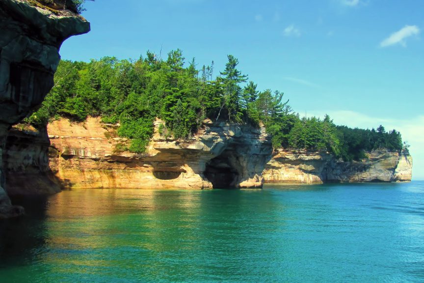
The area is known for the dramatic multi-coloured Pictured Rocks cliffs. When we visited Pictured Rocks National Lakeshore we stayed at Munising Tourist Park Campground.
Munising Tourist Park Campground:
Munising Tourist Park Campground is a city-owned campground on the shore of Lake Superior. It is located 3 miles from the town of Munising.
Site Review:
Munising Tourist Park has 127 sites. There are 78 sites with electric and water hook-ups and 28 sites with electric, water, and sewer. There is a dump station. Campfires are permitted on site and wood can be purchased at the camp office.
Reservations start in October for the next camping season. You can reserve specific sites.
127 scenic sites
78 electric and water Sites
26 electric water and sewer Sites
23 Walk-In Rustic Tent Sites
8 Overflow Sites
We had site #89. It was a full-service site. The site was mere steps from the water, which afforded a nice breeze and a beautiful view of the sunset.
The sites, however, were close together and there was no privacy between sites. Camper Beware there is poison ivy everywhere!
Activities:
Swimming
The beach area was small but functional. It was rocky and pebbly.
Biking
Given how close the campground was to the town of Munising, I had thought that biking into town might be an option. It really wasn’t. In town, the road is relatively flat, but the 3 miles between town and the campground is a highway with narrow shoulders and some fairly substantial hills. Fun metre was probably zero, so we didn’t bother biking at all.
Kayaking/canoeing
It is easy to launch right from your campsite, as well as from the beach- but do remember that this is Lake Superior and the conditions on the lake can vary substantially and change quickly. You can see Grand Island from the Munising Tourist Park Campground. The water was fairly calm on the day we chose to go for a paddle, so we went over to the island to check it out.
Grand Island
Grand Island is approximately 8 miles long and 3 miles across at it’s the widest point. It is the largest island on the south shore of Lake Superior. It is a twenty-mile trip around the island and the perfect place to spend some time exploring.
The Grand Island Ferry runs a shuttle boat service out of Munising that takes you over to Grand Island. It departs every hour in the summer from 9 am until 6 pm. The cost is $15 USD per adult for a round trip.
You can take your own bicycle over to the island, as well as your own kayak, but there is an additional transport fee. You can rent these items from Grand Island Ferry if you do not have your own.
The island provides a combination of rugged dirt/sand trails and easier gravel roads that will accommodate any level of biker or hiker.
The East Channel Lighthouse is located on Grand Island but is only accessible by boat.
Grand Island is definitely worth a visit.
Pictured Rocks
Taking a boat ride with Pictured Rocks Cruises is the best way to view the Pictured Rocks National Lakeshore.
The cruise leaves from the Munising City Dock. Tickets range in price depending on the cruise selected. The Classic Cruise is a 32-mile round trip and affords views of the brilliantly coloured cliffs,
The coloured sandstone walls and caves that make up the Pictured Rocks were created from groundwater and springs rich in minerals such as iron, copper and lime. Leaks out of cracks in the rocks have trickled down the face creating ever-changing natural works of art.
Camping at Pictured Rocks National Lakeshore
There is camping available at Pictured Rocks National Lakeshore but it is rustic. The sites do not have electricity, water or sewer hook-ups. Cell phone reception is limited. Camping is on a first come- first serve basis. They do not take reservations.
All campsites have a picnic table, fire grate, and tent pad. Solar-powered wells provide water. Vault toilets are available.
At Twelvemile Beach and Hurricane River campgrounds, there are sites that look large enough to accommodate some RV rigs but you would be wise to check out site photos and information at the National Park Service.
Arriving early in the morning would give you the best chance of securing a site and that would also be when you would have the best selection. However, July and August are very busy months, so even if you arrive early there is no guarantee that there will be any sites available. It should also be noted that there is no generator use permitted at either of these two campgrounds.
Hiking:
There are numerous trails. There are many waterfalls, beaches, forests, and dunes to explore.
Grand Sable Banks and Dunes
We chose to hike to the Grand Sable Banks and Dunes. Five square miles of Grand Sable Dunes are perched atop the 300 ft. high Grand Sable Banks. You can access the trail directly from the Sable Falls parking lot. You will pass Sable Falls and then hike about half a mile down the canyon to the beach and dune area. (Pets are not permitted on the Sable Falls trail)
Things to Know:
- There is a National Parks Visitor Center in Munising where you can inquire and gather information about the various activities available in the park. (there is another visitor centre – though smaller- near the Sable Falls parking lot)
- To get that brilliantly coloured photo that you see featured on the postcards be sure to book an afternoon cruise. The cliffs are west facing and as the sun lowers in the afternoon you will get the best light for pictures.
- Beware of poison ivy at Munising Tourist Park campground.
- Be cautious of using recreational kayaks or canoes on Lake Superior. Winds and water conditions can change in an instant. Only seaworthy kayaks should be used.
IMO:
I really enjoyed Pictured Rocks National Lakeshore. Munising Tourist Park was the ideal place to camp and enjoy the area. You could take full advantage of the amenities offered at the campground while embracing a view of Lake Superior and Grand Island, as well as have easy access to the Pictured Rocks National Lakeshore.

